Physical map of Umbria

Umbria map

Physical map of Umbria (Italy)

Click on above map to view higher resolution image

About Umbria

Umbria is a region in central Italy. The region is dominated by the ranges of the Appenine mountains (Appennino Umbro-Marhigiano) on the east, and the valley of the Tiber river in the western part.
Major tributaries of the Tiber river include Chiascio, Topino and Nera on the south. The highest point is the peak of Mount Vettore on the border of the Marche, rising to 2476 meters.
Umbria is bordered by Lazio on the south, Marche on the east and north and Tuscany on the west.

The capital is Perugia, other cities in the regions include Terni and Foligno.

Cities: Assisi, Città di Castello , Foligno, Gubbio, Perugia, Spoleto, Terni
Peaks (elevation in meters): Monte Subasio 1290, Monte Pennino 1571, Monte Coscerno 1684, Monte Croce Di Serra 994, Monte Serra Sante 1433, Monte Fionchi 1337, Monte Serano 1429, Monte Torre Maggiore 1120, Monte Tezio 961, Montarale 853
Rivers, lakes: Tiber, Lake Trasimeno
Mountains, regions: Umbrian Apennines, Tiber Valley

Related maps

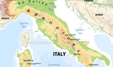
Italy physical map
Italy physical map
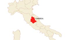
Umbria location map
Where is Umbria located? Map showing the location of Umbria within Italy.
Umbria blank physical map
Blank physical map of Umbria
Umbria geography
Umbria geography map

Customized Umbria maps

Could not find what you're looking for? Need a customized Umbria map? We can create the map for you!
Crop a region, add/remove features, change shape, different projections, adjust colors, even add your locations!
Custom map services
World map illustrator
Europe map illustrator SVG