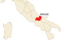
Molise is a region in central Italy.
Its capital is Campobasso, other cities include Isernia, Bojano, Agnone, Larino, Colletorto and Termoli.
Molise is bordered by
Apulia on the east,
Abruzzo and Lazio on the west,
Campania on the south and
the Adriatic Sea on the north.
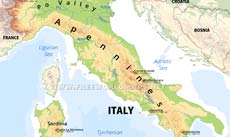
Molise is dominated by the Apennine mountain ranges (Appennino Sannita, Monti del Fretani, Monti del Matese).
The highest paek is Mount Miletto at 2050 meters above sea level, at the border with Campania.
The most important river is the Biterno, flowing across the center of the region.
Cities: Campobasso, Termoli
Peaks (elevation in meters): Monte Miletto 2050, Monte Il Campo 1746, Monte Cesima 1180, Monte Mutria 1823, La Montagnola 1421
Rivers, lakes: Biferno, Trigno, Volturno
Mountains, regions: Samnite Apennines, Matese
Physical map of Molise
Physical map of Molise (Italy)
Click on above map to view higher resolution image
About Molise
Related maps
Customized Molise maps
Could not find what you're looking for? Need a customized Molise map? We can create the map for you!Crop a region, add/remove features, change shape, different projections, adjust colors, even add your locations!


