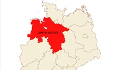
Location: Northwestern part of Germany
Capital: Hannover
Largest cities: Osnabrück, Göttingen, Salzgitter, Braunschweig, Wolfsburg, Oldenburg, Wilhelmshaven
Neighbouring states:
Brandenburg,
Schleswig-Holstein,
Saxony-Anhalt,
Mecklenburg-Vorpommern,
Thuringia,
Hesse,
North Rhein-Westphalia
Neighbouring countries:
The Netherlands
Regions: Lüneburg Heath, East Frisia, East Frisian Islands, Weserbergland, Harz, Emsland
Important rivers: Elbe, Weser, Aller, Ems, Mitteland-kanal
Lower Saxony maps
Physical map of Lower Saxony
Click on above map to view higher resolution image
About Lower Saxony
Related maps
Customized Lower Saxony maps
Could not find what you're looking for? Need a customized Lower Saxony map? We can create the map for you!Crop a region, add/remove features, change shape, different projections, adjust colors, even add your locations!


