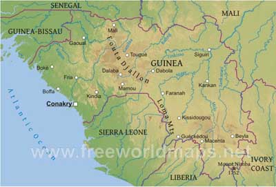
Guinea is located on the Atlantic Coast of West Africa.
The country is divided into four geographic regions: A narrow coastal belt (Lower Guinea); the pastoral Fouta Djallon highlands (Middle Guinea); the northern savanna (Upper Guinea); and a southeastern rain-forest region (Forest Guinea). The Niger, Gambia, and Senegal Rivers are among the 22 West African rivers that have their origins in Guinea.
Mont Nimba is the country's highest point at 1752 meters above sea level.
The capital city is Conakry.
Guinea Physical Map
Physical map of Guinea, equirectangular projection
Click on above map to view higher resolution image
Guinea physical features
Other maps of Guinea
Customized Guinea maps
Could not find what you're looking for? Need a special Guinea map? We can create the map for you!Crop a region, add/remove features, change shape, different projections, adjust colors, even add your locations!


