Emilia-Romagna is a region in central Italy,
lying between the ranges of the Appennine Mountains (Appennino Ligure, Appennino Tosco-Emiliano) and the Po plain, bordered by the Adriatic Sea on the East.
Bologna is the capital of the region. Other important cities include Modena, Parma, Rimini, Piacenza and Ravenna.
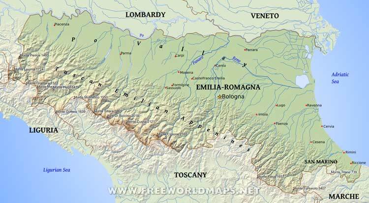
Cities: Bologna, Carpi, Castelfranco Emilia, Cento, Cervia, Cesena, Faenza, Ferrara, Formigine, Imola, Lugo, Modena, Parma, Piacenza, Ravenna, Riccione, Rimini, Sassuolo
Peaks (elevation in meters): Monte Titano 739, Monte Titano 739, Monte Cimone 2165, Monte Maggiorasca 1800, Monte Falco 1657, Monte Lesima 1724, Alpe Di Succiso 2018, Monte Cusna 2121, Monte Gottero 1639, Monte Pelpi 1479, Monte Sillara 1861, Monte Oramara 1522, Monte Fumaiolo 1407, Monte Molinatico 1550, Monte Penice 1460
Mountains, regions, islands: Tuscan-Emilian-Appenines, Po Valley
Rivers, bodies of water: Po, Panaro, Reno, Ligurian Sea, Adriatic Sea
Physical map of Emilia-Romagna
Physical map of Emilia-Romagna (Italy)
Click on above map to view higher resolution image
About Emilia-Romagna
Related maps
Customized Emilia-Romagna maps
Could not find what you're looking for? Need a customized Emilia-Romagna map? We can create the map for you!Crop a region, add/remove features, change shape, different projections, adjust colors, even add your locations!


