Basilicata is a region in southern Italy, between the Tyrrhenian Sea and the Gulf of Taranto.
Its capital is Potenza. Other cities include Melfi, Lavello, Tricario, Matera, Ferrandina, Pisticci, Bernalda, Maratea and Lauria.
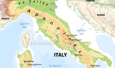
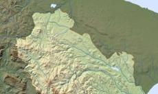
The southern ranges of the Apennine mountain chain runs through Basilicata, the highest point of the southern Apennines being Monte Pollino at 2245 meters above sea level. Monte Vulture on the north is an extinct volcano.
The main rivers are the Basento, Bradano, Sinni and the Agri.
Cities: Matera, Potenza, Avigliano, Bernalda, Lavello
Peaks (elevation in meters): Monte Sirino 2005, Monte Alpi 1900, Monte Volturino 1835, La Spina 1652, Monte Vulture 1326, Monte Crivo 1277, Monte Raparo 1764, Monte Sant Arcangelo 858, Monte Santa Croce 1407, Monte Pollino 2248
Rivers, bodies of water: Bradano, Basento, Agri, Sinni, Gulf of Taranto, Tyrrhenian Sea
Mountains, regions, islands: Campano-Lucano Apennines
Physical map of Basilicata
Physical map of Basilicata (Italy)
Click on above map to view higher resolution image
About Basilicata
Related maps
Customized Basilicata maps
Could not find what you're looking for? Need a customized Basilicata map? We can create the map for you!Crop a region, add/remove features, change shape, different projections, adjust colors, even add your locations!


