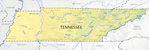
The state of Tennessee is an oblong shaped state, lying the east central parts of the United States. The Mississippi river marks its western border towards Arkansas and Missouri, it also has common borders with the states of Mississippi, Alabama and Georgia on the south, North Carolina on the east, Kentucky and Virginia on the north.
The western regions of the state are characterized by the Mississippi plains, the central part's main river is the Tennessee river, that embraces the Cumberland Plateau and the Highland Rim, while the highest elevations can be found in the eastern regions of the Blue Ridge Mountains, with Clingmans Dome reaching 2025 meters above sea level.
Physical map of Tennessee
Physical map of Tennessee, equirectangular projection
Click on above map to view higher resolution image
Physical features of Tennessee
Other maps of Tennessee
Check our other maps of the state of Tennessee
Customized Tennessee maps
Could not find what you're looking for? Need a customized Tennessee map? We can create the map for you!Crop a region, add/remove features, change shape, different projections, adjust colors, even add your locations!


