Saudi Arabia Physical Map

Saudi Arabia Physical Map

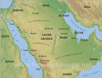
Physical map of Saudi Arabia, equirectangular projection

Click on above map to view higher resolution image

Saudi Arabia physical features

Saudi Arabia is the dominant country of the Middle East and the Arabian Peninsula. The country is covered by deserts almost upon its entire territory.

The central regions of the country and the peninsula is an elevated plateau, called Najd. It is separated form the Red Sea and its narrow coastal plains by higher mountains on the western edges of the peninsula, the Hejaz and Asir Mountains.

The An-Nafud Desert and Syrian Deserts are located north of the Najd region, while the southern desert of the Saudi Arabia Map is called Rub' al Khali Desert, which is the most extensive sand desert on the Earth, stretching over the borders to Oman, Yemen and the Emirates. All of these sub-deserts are sub-sections of the greater non-homogenous Arabain Desert.

Saudi Arabia relief map

Saudi Arabia relief map - black & white shaded relief map of Saudi Arabia
Click to see in higher resolution

Click on above map to view higher resolution image

Other maps of Saudi Arabia

Saudi Arabia HD map
Saudi Arabia map in HD - high resolution physical map of Saudi Arabia
Saudi Arabia location map
Where is Saudi Arabia located? Map showing the location of Saudi Arabia on the globe.
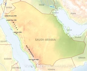
Saudi Arabia mountains
Saudi Arabia mountains - map showing the highest peaks and mountains in Saudi Arabia
Saudi Arabia physical features
Saudi Arabia geography

Customized Saudi Arabia maps

Could not find what you're looking for? Need a special Saudi Arabia map? We can create the map for you!
Crop a region, add/remove features, change shape, different projections, adjust colors, even add your locations!
Custom map services
World map illustrator
Europe map illustrator SVG