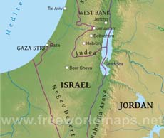
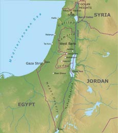
Israel is divided into four regions: the coastal plain, the central hills, the Jordan Rift Valley, and the Negev Desert.
East of the coastal plain lies the central highland region. In the north of this region lie the mountains and hills of Upper Galilee and Lower Galilee; farther to the south are the Samarian Hills with numerous small, fertile valleys; and south of Jerusalem are the mainly barren hills of Judea. The central highlands average 610 meters in height and reach their highest elevation at Mount Meron, at 1208 meters in Galilee
East of the central highlands lies the Jordan Rift Valley, which is a small part of the 6500-kilometer-long Syrian-East African Rift.
Jerusalem is Israel's most important city although most countries have embassies in Tel Aviv-Yafo. Other cities include Haifa and Beer-Sheva. Haifa is Israel's main port. Other ports are Ashdod, Ashkelon and Eilat.
The River Jordan is Israel's main river.
Israel Physical Map
Physical map of Israel, equirectangular projection
Click on above map to view higher resolution image
Israel physical features
Other maps of Israel
Customized Israel maps
Could not find what you're looking for? Need a special Israel map? We can create the map for you!Crop a region, add/remove features, change shape, different projections, adjust colors, even add your locations!


