India Cities, States And Territories Complete Details
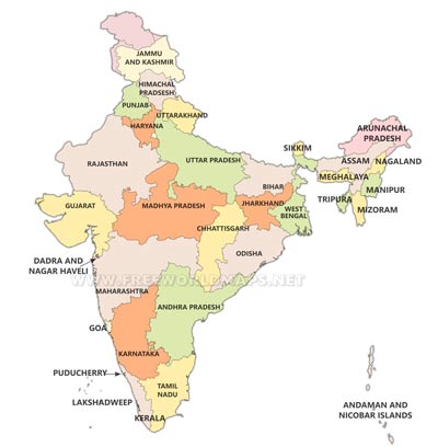
India one of the largest country in World is a republic country with diverse culture. It is one of the largest democracies in World and it is known for its rich and large constitution. India got its freedom in year 1947 on 15th of August. Presently, entire country is divided in 29 States and 7 Union Territory, the states are governed by state government and each state has their own government of operation. State government is headed by central government with President of India and Prime Minister as head of operation.
Cities In India
Ancient India was primarily a village and was known as country of villages. After independence India got its makeover and now it has many cities. Presently, there are number of cities in India and based on its development, cities are categorized as tier 1, tier 2 and tier 3. Tier 1 cities are metropolitan that has all amenities and good life style, good education system and higher quality of life. Here people from across country come in search of education, employment and fun, entertainment. Tier 2 cities are also developed cities with all amenities but employment opportunity and quality of higher education and employment opportunity lower then tier 1. Tier 3 cities are those that are in stage of development.
Major Cities Of Country
There are mainly four metropolitan cities in India naming Mumbai, Delhi, Kolkata and Chennai. Delhi is also the capital of India and political capital too. Maharashtra prominent city Mumbai is economical and entertainment capital of India. Kolkata is one of the largest cities of west India and Chennai one of the largest city of south India. These cities have everything that one can expect. It has rich history with visible imprint, latest technology, higher education, good employment opportunity. All metropolitan cities of India are major tourist attraction and witness local and international tourism throughout the year.
Tier II cities are more like metropolitan but are not officially designated as metropolitans like Bangluru, Lucknow, Bhopal etc. Some of the tier 2 cities are known for its beautiful landscape too.
The Union territories of India are seven in number. Unlike various states of India, Union Territories are directly governed by central government. State does not have legislative assembly to manage its operation. The seven Union territory of India are Andaman and Nicobar Island, Chandigarh, Puducherry, Lakshadweed, Delhi, Daman and Diu, Dadar and Nagar Haveli.
Versatile Weather Of Cities In India
India climate changes from North to South drastically. Therefore, cities of north faces chilled weather in winters and mild in summers. This is because of presence of Himalayan region in North. The cities in South witness hot weather in winter too. They are extremely hot during summers.
In North, India is bordered by Pakistan, China, Nepal and Butan. Its south boundary is sea and in state it has Sri-Lanka. There are many world class heritage sites present in India. Person can see historical imprint of history of India at various places in entire country.


